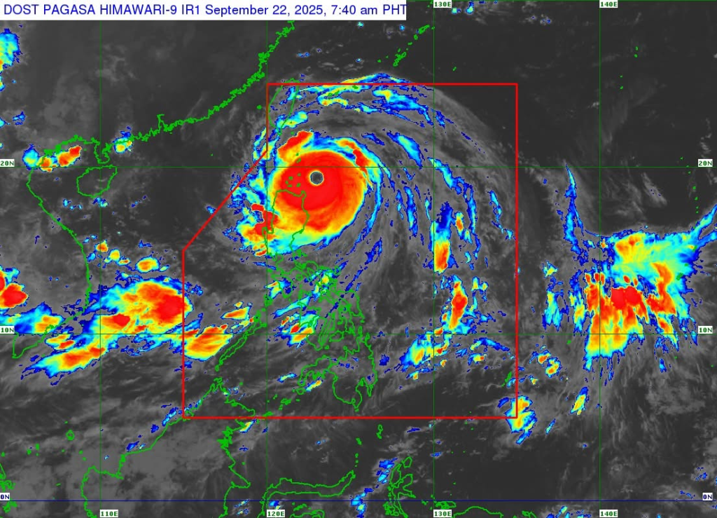
MANILA — Super Typhoon Nando (international name: Ragasa) further intensified early Monday as it moved westward, posing extreme threat to the Babuyan Islands, according to the Philippine Atmospheric, Geophysical and Astronomical Services Administration (PAGASA).
As of 7 a.m., the typhoon’s center was estimated at 180 km east of Calayan, Cagayan, packing maximum sustained winds of 215 km/h near the center, gusts of up to 265 km/h, and a central pressure of 910 hPa. It was moving west at 20 km/h.
PAGASA said typhoon-force winds extend up to 600 km from the center. A landfall or close pass over the Babuyan Islands is possible between noon and early afternoon Monday. Nando may exit the Philippine Area of Responsibility by Tuesday morning.
Wind Signals
- Signal No. 5: Northern and central portions of the Babuyan Islands
- Signal No. 4: Parts of Batanes, rest of Babuyan Islands, northeastern and northwestern Cagayan, northern Ilocos Norte
- Signal No. 3: Rest of Batanes, northern and central Cagayan, northern Apayao, and parts of Ilocos Norte
- Signal No. 2: Isabela, Abra, Kalinga, Mountain Province, Ifugao, parts of Benguet, Ilocos Sur, northern La Union
- Signal No. 1: Quirino, Nueva Vizcaya, Aurora, Nueva Ecija, Bulacan, Tarlac, Pampanga, Zambales, Pangasinan, and northern Quezon including Polillo Islands
Other Hazards
- Storm surge: More than 3 meters possible in Batanes, Cagayan (including Babuyan Islands), Ilocos Norte, and Ilocos Sur.
- Heavy rainfall: To affect Northern and Central Luzon as well as areas impacted by the enhanced southwest monsoon.
- Sea travel: Dangerous across Northern Luzon and parts of Central Luzon, with waves reaching up to 14 meters in Batanes and Babuyan Islands.
PAGASA urged residents in high-risk areas to heed evacuation orders, prepare for life-threatening winds and storm surges, and closely monitor advisories from local governments.
The next bulletin will be issued at 11 a.m.


Leave a comment