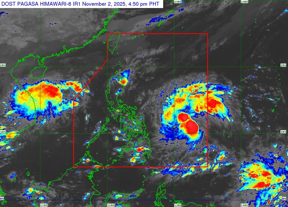
MANILA — Severe Tropical Storm Tino (international name: Kalmaegi) has intensified as it moves westward over the Philippine Sea and may reach typhoon category within 24 hours, the Philippine Atmospheric, Geophysical and Astronomical Services Administration (PAGASA) said Sunday afternoon.
In its 5 p.m. tropical cyclone bulletin, PAGASA said Tino was spotted 805 kilometers east of Eastern Visayas with maximum sustained winds of 95 km/h near the center, gusts of up to 115 km/h, and a central pressure of 990 hPa. It is moving westward at 30 km/h.
Strong to storm-force winds extend outward up to 240 kilometers from the center, the weather bureau added.
Signal No. 1 up in Visayas and Mindanao areas
Tropical Cyclone Wind Signal No. 1 is currently in effect over the following areas due to the threat of strong winds within 36 hours:
- Visayas: Eastern Samar, Northern Samar, Samar, Biliran, Leyte, Southern Leyte, and Camotes Islands
- Mindanao: Dinagat Islands and Surigao del Norte
Residents in these areas may experience strong winds ranging from 39 to 61 km/h, with minimal to minor threats to life and property. PAGASA said the highest wind signal that may be raised throughout Tino’s passage could reach Signal No. 4.
Landfall seen late Monday or early Tuesday
Based on its latest track forecast, Tino is expected to move generally westward and make landfall over Eastern Samar or Dinagat Islands by late Monday (Nov. 3) or early Tuesday (Nov. 4).
After crossing Visayas and northern Palawan, the storm is forecast to emerge over the West Philippine Sea by Wednesday (Nov. 5).
PAGASA warned that Tino may continue to intensify, potentially reaching typhoon category with maximum winds of 150–165 km/h and higher gusts. Rapid intensification within the next 48 hours is possible, and the scenario of Tinoreaching super typhoon strength is not being ruled out.
Rainfall, wind, and storm surge threats
The public was urged to monitor for heavy rainfall and storm surge warnings, as severe winds and flooding are possible even outside the projected landfall area.
PAGASA warned of life-threatening storm surges within 48 hours in low-lying coastal communities across Eastern Visayas, Bicol Region, and northern Mindanao, including parts of Sorsogon, Masbate, Northern Samar, Leyte, Cebu, Negros, and Surigao provinces.
Strong to gale-force gusts are also expected in several areas due to the surge of the Northeast Monsoon, affecting parts of Luzon and Visayas, including Metro Manila, Cagayan Valley, CALABARZON, and MIMAROPA.
Sea travel suspended
Sea travel remains risky to dangerous over the eastern seaboards of Eastern Visayas and Caraga Region, where waves may reach up to 7 meters high, PAGASA said. Mariners of small vessels and motorbancas were advised not to venture out to sea.
PAGASA advised residents, local government units, and disaster management offices to take all precautionary measuresand follow evacuation orders issued by local authorities.


Leave a comment