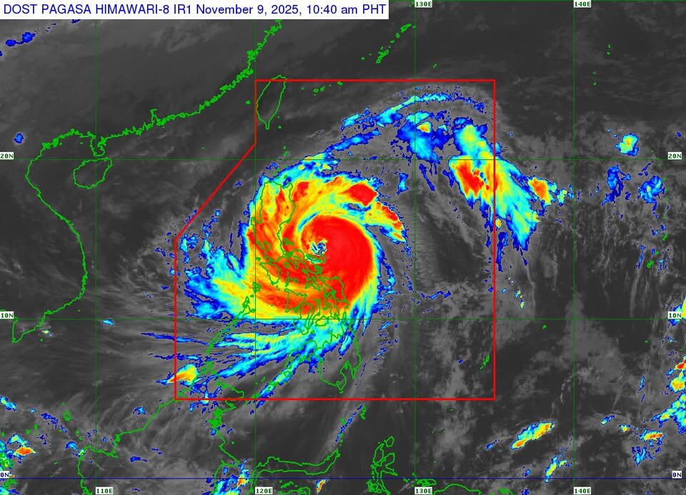
MANILA — Super Typhoon Uwan (international name: Fung-wong) maintained its strength on Sunday morning, November 9, as “life-threatening conditions” continued to affect the Bicol Region, according to the Philippine Atmospheric, Geophysical and Astronomical Services Administration (PAGASA).
In its 11 a.m. tropical cyclone bulletin, PAGASA said the center of Uwan’s eye was estimated over the coastal waters of Pandan, Catanduanes, based on all available data, including those from Baler and Daet Doppler radars.
The super typhoon packed maximum sustained winds of 185 kilometers per hour near the center, gusts of up to 230 kph, and a central pressure of 935 hPa. It was moving west-northwestward at 30 kph.
Strong to typhoon-force winds extended up to 800 kilometers from the storm’s center, PAGASA said.
Areas under highest wind signals
Tropical Cyclone Wind Signal (TCWS) No. 5 was hoisted over Catanduanes; the central portion of Aurora; the Polillo Islands; the northern part of Camarines Norte; and the eastern part of Camarines Sur. These areas may experience “extreme threat to life and property” within 12 hours due to typhoon-force winds exceeding 185 kph.
Meanwhile, TCWS No. 4 was raised over portions of Isabela, Quirino, Nueva Vizcaya, Aurora, Nueva Ecija, Bulacan, Pampanga, Quezon, Camarines Norte, Camarines Sur, and the northeastern part of Albay. PAGASA said residents in these areas face a “significant to severe threat to life and property.”
Metro Manila, Calabarzon, and parts of Central Luzon and Northern Luzon, along with Northern Samar, were placed under Signal No. 3 due to storm-force winds.
Storm surge, heavy rainfall expected
PAGASA warned of a “high risk of life-threatening and damaging storm surge” that could exceed three meters in low-lying and exposed coastal areas in Cagayan, Isabela, Ilocos Region, Central Luzon, Metro Manila, Calabarzon, Bicol Region, and parts of Eastern Visayas and Caraga.
The weather bureau also advised residents to monitor its rainfall and storm surge warnings, with heavy rains expected to trigger flooding and landslides.
A Gale Warning remained in effect over the seaboards of Luzon, the eastern and central seaboards of Visayas, and the eastern seaboards of Mindanao. Seas could reach up to 14 meters in some coastal waters, making sea travel “risky for all types or tonnage of vessels.”
Expected track
PAGASA said Uwan will continue to move west-northwestward, passing close to Calaguas and Polillo Islands before making landfall over the central portion of Aurora province tonight or early Monday.
After crossing Northern Luzon’s mountainous terrain, Uwan is forecast to weaken but remain at typhoon strength as it emerges over the Lingayen Gulf or coastal waters of Pangasinan or La Union by Monday morning.
The typhoon is expected to turn northwestward and then northward by Tuesday before moving toward the Taiwan Strait, where it may make landfall over western Taiwan on Thursday, November 13, and weaken into a remnant low or tropical depression.
PAGASA urged the public and local disaster officials to “take all necessary measures to protect life and property” and to follow evacuation orders from local authorities.


Leave a comment