MANILA — The Philippine Space Agency (PhilSA) is analyzing satellite data to assess the impact of the magnitude 7.8 earthquake that struck southern Mindanao on June 8, 2026.
PhilSA said it has produced maps identifying damaged structures in General Santos City, where areas marked in red indicate possible changes in buildings, structures, or land surfaces as of June 10. The analysis was generated using change detection from Synthetic Aperture Radar (SAR) images captured by the Sentinel-1C and Sentinel-1D satellites of the European Space Agency (ESA).
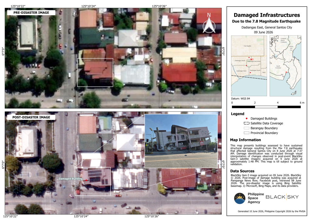
Post-event very high-resolution satellite images also showed specific buildings in General Santos City that sustained structural damage. By overlaying SAR-based change detection results with high-resolution imagery, PhilSA produced maps showing buildings that are likely among the most affected, with suspected damage also marked in red. The agency noted that the findings remain subject to ground validation.
PhilSA also reported evidence of coastal uplift in parts of Sarangani province, including Barangays Burias and Pangyan, where shoreline shifts were detected following the earthquake.
In the maps, the pre-earthquake shoreline was marked in yellow and the post-earthquake shoreline in red, with green markings indicating potentially exposed underwater features. The shorelines were derived through visual interpretation and Automated Water Extraction Index (AWEI) analysis using Sentinel-2C satellite imagery taken on May 10 and June 9, 2026.
The agency also monitored changes in nighttime lights as an indicator of damage and recovery. It said the return of nighttime illumination may signal the restoration of electricity and resumption of activity in affected areas, and could be used as a proxy for tracking reconstruction efforts.
PhilSA said its satellite-based monitoring provides wide-area situational awareness to support the National Disaster Risk Reduction and Management Council (NDRRMC) in prioritizing response and recovery operations.
It added that it will continue monitoring satellite data as needed and urged the public to follow updates from local and national authorities.


Leave a comment