
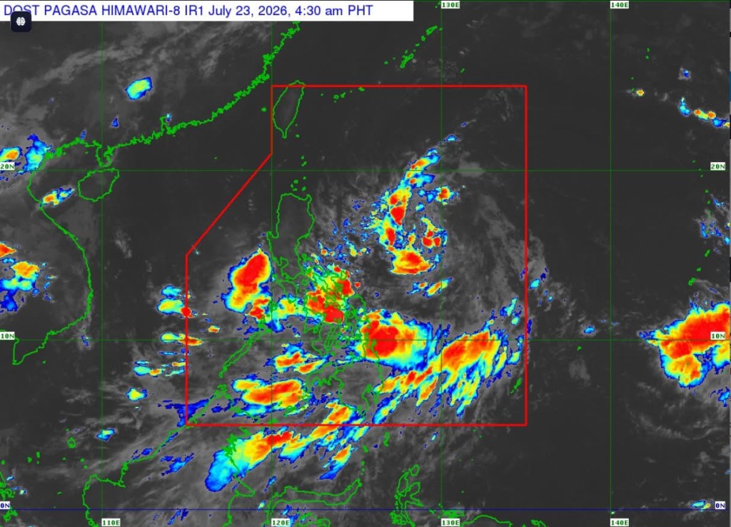
MANILA – Tropical Depression Kiyapo maintained its strength early Thursday as it moved west northwestward over the Philippine Sea east of Central Luzon, with state weather bureau PAGASA warning of possible heavy rains, strong winds and rough seas in parts of the country.
As of 4 a.m., the center of the tropical depression was estimated at 950 kilometers east of Central Luzon, packing maximum sustained winds of 45 kilometers per hour (kph), gusts of up to 55 kph, and moving west northwestward at 20 kph.
Tropical Cyclone Wind Signal (TCWS) No. 1 remains in effect over Batanes; Cagayan, including the Babuyan Islands; Isabela; Apayao; Abra; Kalinga; Ilocos Norte; the northern portion of Ilocos Sur; the northern portion of Aurora; and parts of Mountain Province and Ifugao.
Under TCWS No. 1, winds of 39 to 61 kph are expected within 36 hours, posing a minimal to minor threat to life and property.
PAGASA said the highest wind signal that may be raised during Kiyapo’s passage is Signal No. 2, although Signal No. 3 remains possible if the cyclone intensifies into a severe tropical storm while passing near the Batanes-Babuyan Islands area.
The weather bureau also warned that the southwest monsoon, enhanced by Kiyapo, will bring strong to gale-force gusts over most of Mindanao, Siquijor, Bohol and Southern Leyte on Thursday; most of the country on Friday; and much of Luzon, most of the Visayas, Zamboanga Peninsula, Misamis Occidental, Camiguin, Dinagat Islands and Davao Oriental on Saturday.
Residents were advised to monitor separate weather advisories for rainfall associated with the tropical cyclone and the southwest monsoon.
Meanwhile, rough seas of up to 3 meters are expected along the eastern seaboard of Davao Oriental, where small seacraft, including motor bancas, are advised not to venture out to sea.
Moderate to rough seas are also forecast over the eastern seaboards of Surigao del Sur, Batanes, Cagayan, Isabela, Eastern Samar and Dinagat Islands, as well as the western seaboards of Maguindanao, Sultan Kudarat and Sarangani, and the seaboard of Davao Occidental.
PAGASA said a gale warning may be issued later Thursday or early Friday for the seaboards of Extreme Northern Luzon.
Forecast models indicate Kiyapo will continue moving west northwestward toward the Luzon Strait until Saturday before turning northwestward.
The cyclone may pass very close to northeastern mainland Cagayan between Friday morning and afternoon, then pass near or make landfall in the vicinity of the Babuyan Islands between Friday afternoon and evening. It is expected to exit the Philippine Area of Responsibility by Saturday morning or noon.
Kiyapo is forecast to gradually intensify over the Philippine Sea and may reach tropical storm strength by Friday. It could further strengthen into a severe tropical storm after passing the Babuyan Islands before weakening upon landfall in southern mainland China.
PAGASA urged the public and local disaster risk reduction and management offices to take the necessary precautions and follow evacuation orders and other instructions from local authorities, especially in areas highly susceptible to flooding, landslides and other weather-related hazards.





Leave a Reply