
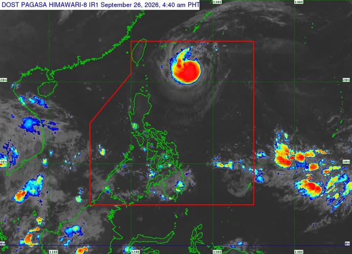
MANILA – Severe Tropical Storm Queenie maintained its strength while slowing down over the Philippine Sea on Saturday, with the weather disturbance forecast to intensify into a typhoon later in the day or Sunday, according to PAGASA.
As of 4 a.m., Queenie was located 600 kilometers east of Itbayat, Batanes, with maximum sustained winds of 95 kph near the center and gustiness of up to 115 kph.
The storm was moving northwestward at 15 kph, with strong to storm-force winds extending up to 280 kilometers from its center.
No Tropical Cyclone Wind Signal (TCWS) was raised over any part of the country, and PAGASA said Queenie was unlikely to directly affect the Philippines throughout the forecast period.
The state weather bureau said Queenie would continue to decelerate while moving north-northwestward over the next 12 hours before turning north-northeastward by Sunday morning.
Queenie is expected to exit the Philippine Area of Responsibility between Sunday afternoon and evening before accelerating northeastward toward the sea east of mainland Japan.
PAGASA said Queenie may intensify into a typhoon Saturday evening or Sunday and strengthen further while moving over waters south of the Okinawa Islands. It is expected to begin weakening by Monday.
Meanwhile, moderate seas of up to 2 meters are forecast over the northern seaboard of Batanes. Mariners of motorbancas and similarly sized vessels were advised to take precautions and, if possible, avoid navigating under these conditions.
PAGASA advised the public and disaster risk reduction and management offices to take necessary measures to protect life and property and to follow evacuation and other instructions from local authorities in areas highly or very highly susceptible to hazards.
The next tropical cyclone bulletin will be issued at 11 a.m. Saturday.





Leave a comment