
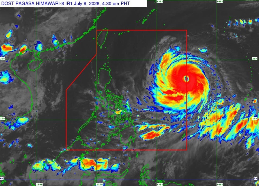
MANILA – Super Typhoon Inday entered the Philippine Area of Responsibility (PAR) early Wednesday, prompting the Philippine Atmospheric, Geophysical and Astronomical Services Administration (PAGASA) to raise Tropical Cyclone Wind Signal (TCWS) No. 1 over parts of Northern Luzon and Catanduanes.
In its 5 a.m. tropical cyclone bulletin, PAGASA said the center of the eye of Inday was estimated at 1,405 kilometers east of Northern Luzon, packing maximum sustained winds of 185 kilometers per hour (kph), gusts of up to 230 kph, and a central pressure of 930 hectopascals. The cyclone was moving westward at 25 kph.
The weather bureau placed the following areas under TCWS No. 1: Batanes; Cagayan, including the Babuyan Islands; the northern and central portions of Isabela; Apayao; the eastern portion of Kalinga; the northern portion of Aurora; and the northern and central portions of Catanduanes.
Under Signal No. 1, winds of 39 to 61 kph are expected within 36 hours, posing a minimal to minor threat to life and property.
PAGASA said the highest wind signal that may be raised during Inday’s passage is Signal No. 2 or 3.
The agency also warned that the enhanced southwest monsoon and the typhoon’s outer circulation will bring strong to gale-force wind gusts over Pangasinan, Zambales, Bataan, Calabarzon, most of Mimaropa, the Bicol Region, most of the Visayas, and most of Mindanao on Tuesday.
By Wednesday and Friday, strong to gale-force gusts may affect most parts of the country.
For rainfall forecasts, PAGASA advised the public to refer to Weather Advisory No. 7 issued at 5 a.m. for the heavy rainfall outlook associated with Inday and the southwest monsoon.
A gale warning is also expected to be issued over the northern and eastern seaboards of Luzon and the Visayas.
Very rough seas of up to 4.5 meters are forecast along the seaboards of Isabela, northern Aurora, northern and eastern Catanduanes, and eastern Northern Samar, where sea travel is considered risky for all types of vessels.
Rough seas of up to 4 meters are expected along the northern and eastern seaboards of Batanes, Polillo Islands, Cagayan, Albay, Sorsogon, Eastern Samar, Dinagat Islands, Aurora, mainland Quezon, Camarines Norte, Camarines Sur, and Northern Samar.
PAGASA advised mariners of small seacraft, including motor bancas, not to venture out to sea under these conditions.
According to PAGASA’s forecast, Inday will continue moving generally westward over the next 24 hours before turning northwestward over the Philippine Sea. The cyclone is expected to make its closest approach to Extreme Northern Luzon by Friday before heading toward the southern islands of Japan and the waters north of Taiwan.
The weather bureau said Inday is forecast to exit the PAR on Saturday and make landfall over the eastern coast of mainland China on Sunday.
PAGASA added that Inday is expected to remain a super typhoon until Wednesday before weakening into a typhoon by Wednesday afternoon or evening. It is forecast to retain typhoon strength throughout the rest of the forecast period.
The agency urged the public and local disaster risk reduction and management offices to take all necessary precautions, particularly in areas vulnerable to flooding, landslides, and strong winds, and to follow evacuation orders and other instructions from local authorities.





Leave a Reply