
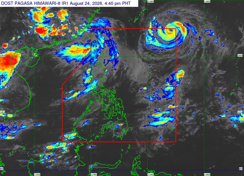
MANILA – Typhoon Obet (Saudel) entered the Philippine Area of Responsibility (PAR) Monday afternoon but is expected to remain far from the Philippine landmass, the state weather bureau said.
In its 5 p.m. Tropical Cyclone Bulletin, PAGASA said the center of Obet was estimated at 1,430 kilometers east-northeast of extreme Northern Luzon as of 4 p.m.
Obet was packing maximum sustained winds of 165 kph near the center, with gusts of up to 205 kph and a central pressure of 945 hPa. It was moving west-northwestward at 30 kph.
Strong to typhoon-force winds extended up to 540 kilometers from the center.
No Tropical Cyclone Wind Signal is currently in effect.
PAGASA said Obet is forecast to continue moving generally west-northwestward over the next two days before shifting generally westward.
Based on the current forecast track, the typhoon will remain far from the Philippine landmass and is expected to exit the PAR within 12 hours.
Despite this, the typhoon is enhancing the southwest monsoon, which is expected to bring strong to gale-force gusts over parts of the country.
On Monday, these conditions may affect most of Luzon and the Visayas, Northern Mindanao, Dinagat Islands, Agusan del Norte, Surigao del Norte, Davao Occidental and Davao Oriental.
Similar conditions are expected across wider areas on Tuesday and Wednesday.
Rough seas
PAGASA also warned of rough seas in several northern and western coastal areas.
Waves may reach 3.5 meters along the seaboard of Batanes and the northern seaboard of the Babuyan Islands, while waves of up to 3 meters are expected along the western Babuyan Islands, northern Ilocos Norte and western Kalayaan Islands.
Moderate seas, with waves reaching up to 2.5 meters, are also forecast in parts of Ilocos Sur, Cagayan, Isabela, Zambales, Pangasinan, Bataan, Lubang Islands, Davao Oriental and other coastal areas.
PAGASA advised operators of motor bancas and similarly sized vessels to take precautions and, if possible, avoid sailing under these conditions.
The weather bureau stressed that heavy rainfall and strong winds may still occur outside Obet’s projected landfall area and forecast confidence cone.
Obet may slightly intensify while inside the PAR but is expected to remain a typhoon. It will subsequently weaken as it moves over southern Japan toward the waters north of Taiwan.
PAGASA forecasts that Obet will make landfall over southeastern mainland China and weaken into a severe tropical storm by Friday, Aug. 28, and into a tropical storm by Saturday, Aug. 29.
The next tropical cyclone bulletin will be issued at 11 p.m. Monday.






Leave a comment