
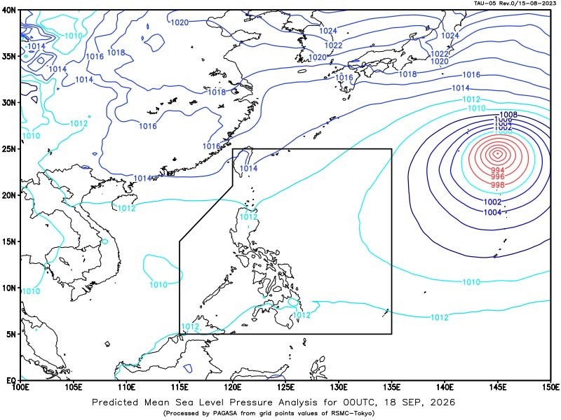
MANILA—A low pressure area (LPA) over the coastal waters of Dumaran, Palawan is expected to bring cloudy skies, rains and thunderstorms over several parts of the country on Friday, the Philippine Atmospheric, Geophysical and Astronomical Services Administration (PAGASA) said.
In its 4 a.m. public weather forecast, PAGASA said the LPA was located at 3 a.m. over the coastal waters of Dumaran, Palawan, at 10.1°N, 120.0°E.
Visayas, MIMAROPA, Bicol Region, Zamboanga Peninsula, Northern Mindanao, Batangas and Quezon will experience cloudy skies with scattered rains and thunderstorms due to the LPA.
PAGASA warned that moderate to at times heavy rains in these areas could trigger flash floods or landslides.
Metro Manila and the rest of the country, meanwhile, will have partly cloudy to cloudy skies with isolated rainshowers or thunderstorms caused by localized thunderstorms. Similar hazards may occur during severe thunderstorms.
Southern Luzon, Visayas and Mindanao will experience light to moderate winds from the southwest to southeast, with coastal waters ranging from slight to moderate at 0.6 to 2.1 meters.
The rest of Luzon will have light to moderate winds coming from the northeast to east, with coastal waters also expected to be slight to moderate at 0.6 to 2.1 meters.
Meanwhile, Severe Tropical Storm Dujuan (2625) was outside the Philippine Area of Responsibility as of 3 a.m. It was located 2,460 kilometers east northeast of extreme Northern Luzon, with maximum sustained winds of 110 kilometers per hour near the center and gustiness of up to 135 kph.
Dujuan was moving northwestward at 55 kph.
For Metro Manila, PAGASA said sunrise will be at 5:45 a.m. and sunset at 5:56 p.m. Moonrise is expected at 11:44 a.m., while moonset will be at 11:03 p.m., with 46 percent illumination.
PAGASA recorded a minimum temperature of 24.7°C and a maximum of 30.4°C during the 24-hour period ending at 8 p.m. Thursday. Relative humidity ranged from 66% to 94%.



 Republika News
Leave a comment