
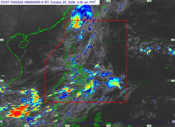
MANILA— Typhoon Rosal (international name: Champi) weakened slightly while over the sea east of Taiwan early Saturday, October 24, but continues to pose strong winds and hazardous sea conditions, particularly in Northern Luzon, according to the Philippine Atmospheric, Geophysical and Astronomical Services Administration (PAGASA).
In its 5 a.m. tropical cyclone bulletin, PAGASA said Rosal was located 420 kilometers north of Itbayat, Batanes, at 4 a.m., with maximum sustained winds of 150 kilometers per hour near the center and gusts of up to 185 kph.
The typhoon was moving southwestward at 10 kph, with strong to typhoon-force winds extending up to 850 kilometers from its center.
Tropical Cyclone Wind Signal No. 1 remains in effect over Batanes, warning of winds ranging from 39 to 61 kph within the next 36 hours. These winds may cause minimal to minor threats to life and property.
PAGASA warned that Rosal’s outer circulation could bring strong to gale-force gusts on Saturday to the Babuyan Islands, Ilocos Norte, Aurora, northern Quezon, the Polillo Islands, the Bicol Region, Romblon, Capiz, Iloilo and Negros Occidental. Similar gusts are expected over Batanes and the Babuyan Islands on Sunday.
A gale warning is also in effect over the seaboards of Northern Luzon.
Sea conditions are expected to be very rough off Batanes, with waves reaching 5.5 meters, and along the northern seaboard of the Babuyan Islands, where waves could reach 4.5 meters. PAGASA advised all vessels to remain in port or seek safe shelter because sea travel under these conditions is dangerous.
Rough seas with waves of up to four meters are forecast along the remaining seaboards of the Babuyan Islands, northeastern mainland Cagayan and northern Ilocos Norte. Other coastal areas in Northern and Central Luzon and parts of the Visayas and Mindanao may also experience rough or moderate to rough seas.
PAGASA advised operators of small vessels, including motorized bancas, to avoid venturing out under hazardous sea conditions, particularly if their boats are ill-equipped or they lack experience navigating rough waters.
The weather bureau said Rosal had completed a counterclockwise loop over the sea east of Taiwan and was expected to accelerate north-northeastward before exiting the Philippine Area of Responsibility on Saturday morning and moving toward the East China Sea.
Rosal is forecast to weaken gradually over the next 12 hours, with rapid weakening expected once it moves over the East China Sea. It could be downgraded to a severe tropical storm by Sunday.
PAGASA reminded the public and disaster risk reduction offices to take precautions against strong winds and other hazards, noting that severe weather may affect areas outside the typhoon’s forecast track. Residents in high-risk areas were urged to follow evacuation orders and other instructions from local authorities.
The next tropical cyclone bulletin was scheduled for release at 11 a.m. Saturday.




Leave a Reply