
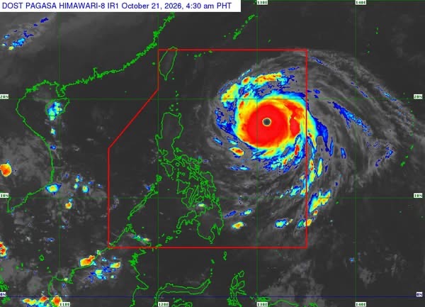
MANILA— Super Typhoon Rosal continued to strengthen over the Philippine Sea early Wednesday, accelerating to 30 kilometers per hour as it moved toward Extreme Northern Luzon, according to the Philippine Atmospheric, Geophysical and Astronomical Services Administration (PAGASA).
In its 5 a.m. tropical cyclone bulletin, PAGASA said Rosal was located 990 kilometers east of Northern Luzon at 4 a.m., with maximum sustained winds of 215 kph near the center, gusts reaching 265 kph, and a central pressure of 900 hectopascals.
The weather bureau said the cyclone was moving west northwestward, with strong to typhoon-force winds extending up to 780 kilometers from its center.
Tropical Cyclone Wind Signal No. 1 was raised over Batanes, the Babuyan Islands, parts of Ilocos Norte, Cagayan and Isabela, and northeastern Catanduanes, warning of strong winds ranging from 39 to 61 kph within the next 36 hours.
The areas under Signal No. 1 include Pagudpud in Ilocos Norte; the northern and eastern portions of mainland Cagayan; Maconacon, Divilacan and Palanan in Isabela; and Pandan, Bagamanoc, Panganiban, Viga and Gigmoto in Catanduanes.
PAGASA said the highest wind signal that may be raised during Rosal’s passage is Signal No. 2 or 3.
Strong winds, rough seas expected
The bureau warned that the combined effects of the northeasterly wind flow and Rosal’s outer circulation would bring strong to gale-force gusts to several parts of the country through Friday.
On Wednesday, affected areas include the Ilocos Region, Cordillera Administrative Region, Cagayan Valley, Bicol Region, Romblon, Eastern Visayas, Siquijor, Bohol, Northern Mindanao, Caraga, Davao Region and Sarangani.
On Thursday, strong gusts are expected over most of Luzon and the Visayas, as well as Zamboanga del Norte, Northern Mindanao, Agusan del Norte, Surigao del Norte, Dinagat Islands, Sarangani, Davao Occidental and Davao Oriental.
By Friday, the same conditions may affect most of Luzon and the Visayas, Camiguin, Misamis Occidental, Lanao del Norte, Dinagat Islands, Davao Occidental and Davao Oriental.
PAGASA also said a gale warning remained in effect over the northern and eastern seaboards of Luzon and the eastern seaboard of the Visayas.
Very rough seas, with waves reaching up to eight meters, are forecast along the seaboards of Batanes and the northern and eastern coasts of Cagayan, including the Babuyan Islands.
Waves may reach up to six meters along the remaining seaboards of Cagayan and the coast of Isabela, while seas of up to five meters are expected along the eastern seaboard of northern Aurora and the northern and eastern coasts of Catanduanes.
The bureau warned that sea travel would be risky for vessels of all types and tonnage in these conditions, advising mariners to remain in port or seek shelter or safe harbor until winds and waves subside.
Small seacraft operators, including those using motorized bancas, were also advised against venturing out into areas where waves could reach four meters. Precautionary measures were recommended for smaller vessels navigating waters with waves of up to 2.5 meters.
Rosal may weaken by Sunday
PAGASA said Rosal would continue moving west northwestward on Wednesday before turning northwestward until Friday morning and recurving northeastward by Sunday.
Based on the forecast track, the cyclone is expected to come closest to Extreme Northern Luzon between Thursday and Friday afternoon before leaving the Philippine Area of Responsibility by Friday evening or early Saturday.
Further intensification remains possible within the next six hours as Rosal moves over the Philippine Sea, but a weakening trend is expected afterward. It is forecast to weaken into a typhoon on Thursday and a severe tropical storm by Sunday.
PAGASA emphasized that heavy rainfall and severe winds could still affect areas outside the cyclone’s landfall point and forecast confidence cone.
The agency urged the public and disaster risk reduction and management offices to take necessary precautions to protect lives and property. Residents in areas highly or very highly susceptible to hazards were advised to follow evacuation orders and other instructions from local officials.
The public was also urged to monitor rainfall warnings, thunderstorm advisories and other localized weather updates from PAGASA’s regional services divisions.
The next tropical cyclone bulletin is scheduled for release at 11 a.m. Wednesday.






Leave a Reply